Finding Mount Sinai
(1) Where is Mount Sinai Located?
Abstract: Our approach to the location of Mount Sinai was by finding the Midianite pasture lands. This was done through the synthesis of a plethora of biblical and archaeological evidence as well as early Islamic literature. It led to the selection for Midian of a more northeastern location than the current consensus of biblical scholars. That choice unexpectedly resulted in a plausible explanation for the burning bush, allowed us to identify Suf, is consistent with the traditional site of Moses’ well and is supported by more petroglyphic evidence than is found in St. Catherine’s in the Sinai Peninsula, or Mount al-Lawz or al-Badr in western Saudi Arabia, or in a Negev location in Israel.
(2) Historically Abraham sojourned between Kadesh and Shur spending time in Beersheva. Abraham sent his son Midian eastward from this location, to live away from his son Isaac, some 400 years previous to the Exodus. Genesis 25:1- 6. Esau (Edom) went in the same direction to Mount Seir Genesis 36:6-12, Ishmael moved to the wilderness of Paran, (Ma’an) at least as far as Dumah and Kedar, towns which bear his sons’ names to this day along the wadi Sirhan. Midianites and Ishmaelites appear to have intermarried, which would put both in the same region between the Kings Highway and the Sirhan wadi Judges 8:22-24, Genesis 37:28, Genesis 21:21. Paran’s location can be seen in Genesis 14:6,7 where Kedorlaomer went through Seir as far as Elparan by the wilderness and then returned to Kadesh. In Deuteronomy 1:1-5 Paran is mentioned along with Suf as being in Moab, in Trans Jordan בעבר . Lot’s daughters fled with their father from Sodom towards Zoar and then eastward to Mu’ab (Moab), Dibon (Dhiban) and Amman. These cities of their descendants retain their biblical names to this day. Many scholars, including Sir Colin Humphreys, conclude that the escarpment of Seir is in fact the most reasonable location for Shur, the wall before Egypt.
(3) Moses, upon fleeing Egypt at the age of 40, chose to go eastward to Midian and stayed with Reuel also known as Jethro priest of Midian his father-in-law and Hobab his brother-in-law for 40 years. There he accumulated a wealth of knowledge of local conditions, geography and customs. It is from there that Moses pastured Jethro’s herds Ex 3:1 It was there in Midian where he established his family with Zipporah. Ex 2:21,22. It was there, behind, or far away into, the wilderness pasture lands utilized by the Midianites, where Israel, a pastoral people, could pasture their animals. There Moses was commanded by the Lord to bring the Children of Israel to worship. Ex 3:12 It was there where they received the law and discovered, the very reason for their existence, which was to “love the Lord your God with all your heart and with all your soul and with all your might” Deuteronomy 6:5.
(4)Where is Midian and where are their wilderness pasture lands? That is the real question, since it is there, where we will find Mount Sinai. At the time of the Exodus, Midian and Moab were neighbors, who together employed Baalam to curse Israel. Numbers 22:4,7. They both must have been close enough geographically to feel threatened by Israel’s presence while Israel was camped across from Jericho in the plains of Moab. This is a clear biblical indication that the Moab and Midian of Moses’ time were located near the plains of Moab. They were clearly justified since after the matter of Cozbi, the Midianite princess, Moses sent the children of Israel to destroy Midian from the plains of Moab. Numbers 31:3. Israel skirted Moab and Edom to the east before conquering the Amorites Judges 11:18. These passages demonstrate that Midian lived further north than is currently thought and lay to the east of Moab who’s eastern border was the King’s Highway, so The pasture lands of Midian must necessarily be eastward of the King’s Highway, into the wilderness of Ma’an, Harrat al-Harrah, and Harat Ash-Shammah, because to the north lived the Amorites, Numbers 21:13. The Ammonites had been displaced northward to the Jabbock and their cousins the Moabites southward by the Amorites at the time of the Exodus and so occupied the Arnon Basin east of the Dead Sea between Arnon and Mu’ab. To the South the Edomites occupied Mount Seir and Ishmaelites lived further eastward in the wilderness of Paran as far as Dumah. Gen 21:21 Petroglyphically the tribe of Hobab, Moses’ brother-in-law later identified themselves as pasturing their animals 80 miles ENE of Amman Jordan to as far as 15 miles east of Ayla. AAEK 104 krc.orient.ox.ac.uk Safaitic page 29.
(5) Dan Gibson correctly points out that Paran is clearly distinct from the wilderness of Sinai with both Kibroth-Hattaavah and Hazeroth in between. The extensive distribution of Midianite pottery has all been dated to 13th and 12th century BC, the time of Gideon 1214 -1208 BCE not the time of Moses 1446 BCE as noted by Sawyer and Cline in “Midian Edom and Moab” Page 114 and therefore is a later distribution of Midian. The Kings Highway which separates the Moabites and Edomites from the Midianites and Ishmaelites contains Moses’ well which rather than being the Rock of Horeb is more likely where Moses met Zipporah since the Midianites pastured in the wilderness to the east and would have watered their flocks at the less arid heights on the west side of the wilderness.
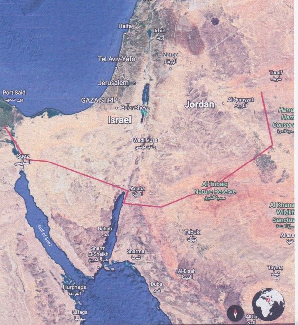
(6) In the most probable route of the Exodus, Moses and the Israelites avoided confrontation with the Egyptians and with tribes of their own ancestors by taking more difficult and less populated circuitous routes such as the Red Sea wilderness instead of the way of Horus and the wilderness of Shur and Sin instead of a direct route through Seir Exodus 13:17,18. From the now silted in bifurcate extensions of the Red Sea at Aqaba (Ayla) they went into the Wilderness of Shur, Ex 15:22 and then to the Red Sea at Haql and then into the wilderness of Sin ( al-Tubaiq Nature reserve) on their way to Sinai. From the wilderness of Sin, they went eastward to Rephidim a “spread out” plain where they were attacked by the Amalekites, Ex 17:8 a tribe of Edomites. I Chronicles 1:35,36 The Amalekites lived in the land of the Negev but also east of the Arabah, Judges 6:33 preying on travelers of the ancient trade routes. 1 Samuel 15:2 From Rephidim the Israelites would have traveled to the dividing border between Paran and the wilderness of Sinai. (Numbers 33:15) then to its far side at Aqran or closer still to Black stone Mountain. They had 56 days to accomplish this journey arriving the same day they left Egypt but two months later. Ex 19:1.
(7) A year later the Lord sent Moses to Hazeroth. Hazeroth means a “settlement”. The location currently called Al-Azraq a similar sounding name, has been occupied for millennia and had enough water and pasture for Israel’s herds. It represents the basin of the drainage for most of the areas to the west and south since it has perennial marshes is likely the Suf Deuternomy. 1:1 recorded alone without yam. It is located on a migratory bird flyway which would explain the events at Kibroth-Hattaavah. It is also located in the northern corner of Paran, which was the next stop on the journey to Kadesh Barnea. Importantly,
when the spies returned from Canaan they came to Moses and Aaron in Paran toward Kadesh Nu 13:26 פארן קדשה near Ma’in but not in Kadesh due to the directional Hey ה. When they returned from Kadesh Barnea they went to the wilderness taking the Red Sea road through Ayla avoiding Seir. Nu 21:4 Deut 2:1
(8) The description of Mount Sinai has long been recognized as volcanic Ex 19:16-19, just as the cherubim may be. We began our search for mount Horeb there, looking for a volcano, which was active in 1446 BCE or at a minimum, the fire of a natural gas seep such as is found in Baba Gurgur. The volcanic wilderness fields in this area are covered with inscriptions of earlier and later periods. The names Gad and Rueben, Horeb, Hobab, Bashan, and Midbar are well attested to there (OCIANA Oxford) supporting a trans Jordan location for Sinai. That places Sinai proximate to, but separate from, Edom and Moab and clearly trans Jordan as does Deuteronomy 33:2 and Habakkuk 3:3. We then identified several volcanoes on the far side of the wilderness pasture lands of Midian.
(9) Aqran mountain, western Jouf province volcanoes and Black Stone were selected for the following reasons. Going through Seir, (the direct route) they are within 11 days journey from Kadesh Barnea. Deuteronomy 1:2 they are within pasture range of Wadi Sirhan, which we identify as Midianite and are east of Moab. They are volcanoes. Aqran is near the natural gas fields of Turaif a possible etiology of the burning bush, which the angel of the Lord used to get Moses’ attention. It has two streams coming from its now eroded volcanic cone and a cistern on top. These are necessary characteristics, since Moses under the Lord’s direction produced water from the rock at Horeb and forced the Israelites to drink from the brook of Mount Sinai after pounding the golden calf to dust. Deuteronomy 9:21 The streams have numerous Cairn indicating Holy places. Mount Sinai is called ٱلطُّورِ Mount Tur in the Quran 28:29 and possibly associated with the town, native Arabic dialect, and tribe of Turaif which are just east of Mount Aqran. جبل أقرن The Quran indicates Moses approached Sinai from the south. GHG satellite imagery however indicates more methane is found on the north side of Aqran among the sonographic test patterns of the recently discovered natural gas fields.
(10) The petroglyph inscriptions throughout northern Arabia as well as into Jordan and Syria, are primarily Safaitic but also Dadanitic, Hismaic, Taymanitic, and Thamudic with some Greek as well as Nabatean, all from later time periods and artwork from earlier time periods depicting animals. The Hebrew inscription at Jabal Jubbbah discovered by Julius Euting in the late 19th century appears to be of later time period. Its main support comes from being close to Teman Saudi Arabia although the Teman of Habakkak 3:3 is associated with Paran and that of Amos 1:12 is clearly Bozrah which is indisputably modern Basira of Seir. After reviewing these locations, John Shreier discovered that the Google Map indicated Napatian but more probably Nabatean writing had been previously found 5 miles north of Aqran near indications of agriculture. This indicates how Moses met and married the Kushite woman after Sinai along this ancient Napatian trade route to Mesopotamia, which also includes the Sirhan Wadi. Here Ishmael’s oldest sons Nebaioth’s descendants (the Nabateans) Dumah and Kedr still carry their names and indicate their presence in the wilderness of Harrat al Harrah as well as the wilderness of Ma’an which we Identify as Paran. The Mount Sinai covenant was allegorized by Paul to Hagar the mother of Ishmael which may indicate a geographic relationship of the Ishmaelites to Mount Sinai in Arabia. Galatians 4:25
11) In conclusion Mount Aqran, and to a lesser extent the volcanoes of western Jouf province or Black stone Mountain are the best choices for the true location of Mount Sinai. Al Badr is too far from the plains of Moab and would not make sense if Seir is an intermediate stop nor does it have natural gas but otherwise would be an excellent choice and is favored by Colin Humphreys. Further archeological research of inscriptions at these locations are needed. A reference to the Israelite sojourn at Sinai may be found among them. These reinforce the belief that the red Sea crossing occurred at Ayla. The archaeological exploration of Ayla for the crossing site of the Red Sea would allow the identification of the Pharaoh of the Exodus in this most central biblical event.