Finding Ezion-Geber
Finding Eziongeber
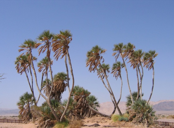
Eziongeber is mentioned in the Bible as the location where King Solomon constructed a navy of ships. He sent them to Ophir to trade for gold. King Jehoshaphat attempted to do the same, but his ships were destroyed at Eziongeber. According to Josephus it was because they were too large. The town of Eziongeber, also written Eziongaber and often hyphenated, is noted to be near Eloth. 1 Kings 9:26. King Solomon visited Eziongeber and then Eloth going south from Jerusalem, which indicates Eziongeber is to the north of Eloth. 2 Chronicles 8:17. In Deuteronomy 2:8, the children of Israel are going north up the Arabah from Elath (Eloth) and then Eziongaber on their way to Moab, which also indicates the location of Eziongaber is north of Eloth. Since his prior camp was at Abronah, indicating a crossing, Eziongeber could have been on either side of the Arabah. Ezion geber is noted to be on the shore of the Red Sea and a deep water port, so the Sea has doubtlessly been displaced to the south by the silting in of the Arabah from the north. Edward Hull the Irish explorer felt the sea extended 15 miles up the Arava in the past. Many alluvial fans are evident by satellite imagery on both sides of the Arabah. The reduction in plant life from subsequent reduction in rainfall would have made the desert more susceptible to erosion and this would have accelerated considerably in the three and a half millennia since the time of Moses. The name Eziongeber means “spine of a giant” or more precisely “spine of a warrior”. If the name Ezion-geber is taken to be descriptive, a white ridge a few kilometers north of the kibutz Eilot on the west side of the Arabah, which does appear to be a spine and sacrum, would indicate its location. It currently includes Mount Amir and Giv’ at Bahat. The Amram Nahal crosses the center of the spine and terminates at the salt flats in the Arava below. The shipyards as well as any wreckage from Jehoshaphat’s misadventure would be under 50 -70 feet of gravel fill from the silting of the Red Sea north of Eilat. Although there are several wadi, which could then have been the water supply for Eziongeber shipyard, the wadi Amram is the most likely. Wadi Tsfunot feeds the palms at the Dekel Dom nature reserve so the palm grove seen at Dekel Dom may also be or had been a part of Eziongeber. These particular palms are noted by 19th century explorers and were peculiar to the seashore at Ayla. Currently the city of Aqaba is considered by most to be Eloth also labeled as Ayala on ancient maps and was the other known source of permanent water. Its source was the wadi Yutim of the pass at Aqaba from which the Jordanian city gets its name.. Water coming down the Arabah and evaporating has accumulated salt brine in the Arabah from Eilat to about 6.5 miles north of Eilat. The Red Sea would have been the widest at this point but as mentioned is 50- 70 feet above sea level today. Just below Dekel Dom the water is brine, so this most likely marks the shoreline at Etzion Geber. Dekel Dom is located 7 miles north of Eilat. Pharoah’s Island is much further to the south. It has been proposed as Etzion Geber but it is without drinking water, and would make construction at that site difficult, as would transporting materials from the mainland to build a fleet, so it is ruled out as a location for Ezion geber. Excavating 70 feet of gravel in brine will make an archaeological confirmation of the location of Etzion Geber difficult at best. However it is where the shipwrecks of Jehoshaphat should be located. Pi Hahiroth is located halfway between Dekel Dom and Etzion Geber (the seaport of Solomon ) and Tel el-Kheleifeh (the signal tower for ships coming to load copper from Timmna). As such it is also a marker for Pi Hahiroth “between the Sea (port of Solomon) and Migdal. “